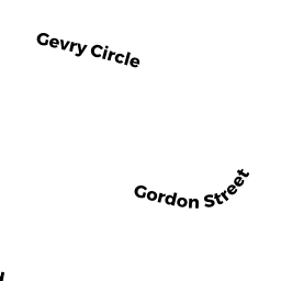
76 GORDON ST
Owner Information
ALLEN PAULA ETUX
76 GORDON ST
LEOMINSTER, MA 01453


Property Details
76 GORDON ST is classified as a Single Family Residential (Ranch).
The primary structure on this property was built in 1979. There are 3,203ft2 of built area within this property. There is 1,232ft2 of residential/living space within this property. This property is listed as having 6 rooms.
76 GORDON ST is valued at $336,200. The land is valued at $112,300 and the structures are valued at $216,800. There is an additional valuation of $7,100 on this property.
This property is in Zone RA. Confirm with local Zoning Board authorities to ensure there are no overlays or other easements on this property.
The most recent deed for 76 GORDON ST is recorded at the local registrar in Book 9074, Page 004. 76 GORDON ST was last sold on Thursday, May 17, 2018 for $290,000.
Assessment data from fiscal year 2021.
Flood Data
According to the FEMA National Flood Hazard Layer, this property does not appear to be in a flood zone. It may also be in an area not yet reviewed. Nonetheless, confirm this information prior to taking any action.
To view the flood hazards around this property, create a FEMA "Firmette" Map of the area around 76 GORDON ST.
Broadband Internet Providers
| Provider | Type | Bandwidth (mbps) | |
|---|---|---|---|
| Comcast | Cable | 1000 | 35 |
| Verizon New England Inc. | Fiber | 940 | 880 |
| Verizon New England Inc. | DSL | 5 | 0 |
| VSAT Systems, LLC. | Satellite | 2 | 1 |
| Viasat Inc | Satellite | 100 | 3 |
| HughesNet | Satellite | 25 | 3 |
| GCI Communication Corp. | Satellite | 0 | 0 |
| T-Mobile | Fixed Wireless | 25 | 3 |
Broadband service provider data from December 2020.
Adjacent Properties
- 82 GORDON ST
Single Family Residential owned by CROTTY MARK A & SUSAN M TRS - 70 GORDON ST
Single Family Residential owned by LANDRY ROBERT J ETUX - 71 BIRCHCROFT RD
Single Family Residential owned by GONZALEZ, LUIS NAJERA - 75 BIRCHCROFT RD
Single Family Residential owned by INAM MAGDALINE BARONG ET UX - 81 BIRCHCROFT RD
Single Family Residential owned by SHORTSLEEVE RICHARD J L/E